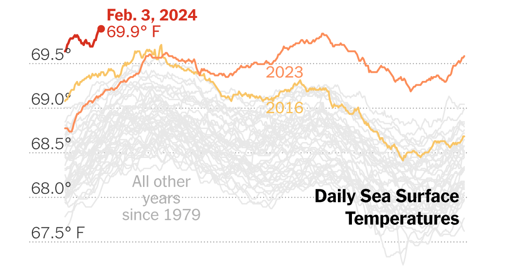
The exceptional warmth that first enveloped the planet last summer is continuing strong into 2024: Last month clocked in as the hottest January ever measured, the European Union climate monitor announced on Thursday.
It was the hottest January on record for the oceans, too, according to the European Union’s Copernicus Climate Change Service. Sea surface temperatures were just slightly lower than in August 2023, the oceans’ warmest month on the books. And sea temperatures kept on climbing in the first few days of February, surpassing the daily records set last August.
The oceans absorb the great majority of the extra heat that greenhouse gases in the atmosphere trap near Earth’s surface, making them a reliable gauge of how much and how quickly we are warming the planet. Warmer oceans provide more fuel for hurricanes and atmospheric river storms and can disrupt marine life.
January makes eight months in a row that average air temperatures, across both the continents and the seas, have topped all prior records for the time of year. All in all, 2023 was Earth’s hottest year in over a century and a half.
The principal driver of all this warmth is no mystery to scientists: The burning of fossil fuels, deforestation and other human activities have driven the mercury steadily upward for more than a century. The current El Niño weather cycle is also allowing more ocean heat to be released into the atmosphere.
Yet precisely why Earth has been this hot, for this long, in recent months remains a matter of some debate among researchers, who are waiting for more data to come in to see whether other, less predictable and perhaps less understood factors might also be at work around the margins.
“Rapid reductions in greenhouse gas emissions are the only way to stop global temperatures increasing,” Samantha Burgess, Copernicus’s deputy director, said in a statement.
According to Copernicus’s data, temperatures in January were well above average in eastern Canada, northwestern Africa, the Middle East and Central Asia, though much of the inland United States was colder than usual. Parts of South America were warmer than normal and dry, contributing to the recent forest fires that devastated central Chile.
The intensity of recent underwater heat waves prompted the National Oceanic and Atmospheric Administration in December to add three new levels to its system of ocean heat alerts for indicating where corals might be bleaching or dying.
An El Niño pattern like the one currently observed in the Pacific is associated with warmer years for the planet, as well as a swath of effects on rainfall and temperatures in specific regions.
But as humans heat up the planet, the effects that forecasters could once confidently expect El Niño to have on local temperatures are no longer so predictable, said Michelle L’Heureux, a NOAA scientist who studies El Niño and its opposite phase, La Niña.
“For regions that previously tended to have below-average temperatures during El Niño, you almost never see that anymore,” Ms. L’Heureux said. “You see something that’s more near-average, or even still tilting above average.”


